
Community Guide
The Chestatee River Arm is the northern Lake Lanier finger that runs out of Dawsonville and northern Hall County into Dawson County, formed where the Chestatee River meets the Lake Lanier reservoir managed by the U.S. Army Corps of Engineers Mobile District at full pool elevation 1,071 feet above mean sea level (USACE Mobile District, current as of May 2026). Homes along the Chestatee arm trade on quiet coves, wooded shoreline, retreat-style privacy, and shorter drives to the North Georgia mountains than the southern Lake Lanier basin in Forsyth County and southern Hall County offers. Buyers shortlisting the Chestatee arm typically want lake access without the southern-basin density.
Living Along the Chestatee River Arm
Living on the Chestatee River Arm means trading the southern basin's marina density, restaurant footprint, and Atlanta-direction commute time for wooded shoreline, fewer boats on weekday water, and direct access to Dawsonville, the North Georgia Premium Outlets corridor, and the GA-400 pull into the mountains. The arm sits primarily in Hall County and Dawson County, with the upper reaches running toward Dahlonega.
Dawsonville, North Lake privacy, and retreat-style lake living
Dawsonville sits at the head of the Chestatee River Arm in Dawson County, and the homes along this stretch of Lake Lanier shoreline lean toward retreat-style use rather than primary-residence Atlanta-commute use. Lots tend to run larger, the tree canopy is heavier, and the lake-facing parcels often back up to wooded ridge rather than to an adjacent subdivision. The Dawsonville commercial footprint along GA-400 includes the North Georgia Premium Outlets, the Dawsonville town square, and the Atlanta Motorsports Park, which gives buyers errand-radius access without putting them inside a dense suburban corridor. North Lake privacy is the defining product on the Chestatee arm. The shoreline orientation, the wooded cove depth, and the lower marina density together produce a noticeably quieter lake experience than buyers find on the southern basin near Aqualand Marina, Holiday Marina, or Lake Lanier Islands. Boat traffic on a typical summer Saturday on the upper Chestatee arm runs at a different cadence than boat traffic on the southern Buford or Cumming shoreline, and buyers prioritizing a quieter weekend lake usually shortlist the Chestatee or Chattahoochee arms first. Retreat-style lake living also fits the way many Chestatee buyers actually use the home. The arm pulls a meaningful share of second-home buyers from Atlanta and the Southeast feeder markets who want a Friday-evening-to-Sunday-evening cadence without a 90-minute pull from the city. Drive time from a typical Chestatee arm address to the Perimeter (I-285) via GA-400 runs roughly 75 to 110 minutes depending on the day and the specific cove location (Georgia Department of Transportation, current as of January 2026), which fits weekend and seasonal use better than five-day in-office cadence.
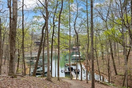
Quiet coves, wooded shoreline, and North Georgia access
The Chestatee River Arm's coves are structurally quieter than the southern basin's because the lake narrows as it runs north and the marina infrastructure thins out. The upper coves in Dawson County and northern Hall County frequently sit at the end of long no-wake fingers, which keeps wake-boat traffic limited and gives waterfront homes a calmer dock experience. Shoreline orientation matters more on the Chestatee arm than on the southern basin because cove depth at full pool 1,071 varies sharply between parcels that sit on a deep main-arm channel and parcels that sit on a shallow upper finger. Wooded shoreline is the visual signature of the Chestatee arm. Much of the surrounding land remains heavily forested, with hardwood and pine stands running down to the Corps Line, and the dominant home orientation is set back into the trees rather than perched on a cleared lawn. Buyers who want a North Georgia woodland feel rather than a manicured suburban lake feel typically prefer this stretch of the shoreline over the more cleared southern parcels in Forsyth County or southern Hall County. North Georgia access is the third structural advantage. Dawsonville sits at the gateway to the Chattahoochee National Forest, Amicalola Falls State Park, Dahlonega's wine country, and the Blue Ridge mountain corridor along GA-400. A Chestatee arm address puts the buyer roughly 30 minutes from Dahlonega and roughly 45 minutes from the Amicalola Falls and Springer Mountain trailhead, which positions the lake home as a base for both water recreation and mountain recreation in a way the southern shoreline does not match.
How the Chestatee arm compares with Gainesville and South Lake areas
The Chestatee River Arm and the Gainesville-area south-lake shoreline both sit on Lake Lanier, but they answer different buyer questions. The Gainesville south-lake area, anchored by the city of Gainesville in Hall County and the Sunrise Cove, Chattahoochee Country Club, and Chestatee Bay neighborhoods, sits closer to Northeast Georgia Medical Center, Brenau University, the Gainesville commercial center, and the I-985 corridor into the metro. Daily-life logistics on the Gainesville side run on a different scale than the Dawsonville side, with denser dining, retail, and healthcare infrastructure inside a shorter drive radius. The southern Lake Lanier basin, which includes the Buford and Cumming shoreline in Hall, Gwinnett, and Forsyth counties, sits closest to the Atlanta metro and supports a primary-residence and hybrid-work cadence that the Chestatee arm typically does not. Permitted-dock waterfront on the southern shoreline ZIP codes 30518, 30519, 30506, 30542, and 30040 across Buford, Cumming, Flowery Branch, Gainesville, and Sugar Hill carried a median listing price of approximately $1,250,000 as of March 2026 (Georgia MLS, March 2026). The Chestatee arm's median typically runs below the southern-basin median on a like-for-like dock class, reflecting the longer Atlanta drive and the smaller daily-life footprint. The comparison usually resolves on use pattern. Buyers who plan to commute to Atlanta two or more days a week, who want broad school assignment choice across Forsyth and Hall counties, or who want a shorter drive to North Atlanta dining and retail lean toward the southern basin or the Gainesville-area shoreline. Buyers who want a quieter cove, a wooded lot, retreat-style cadence, and a shorter drive into the North Georgia mountains lean toward the Chestatee arm. The two markets rarely tie once the buyer is honest about how the home will be used.
What Buyers Should Know
Buyers shortlisting the Chestatee River Arm should price four variables into the underwriting before writing an offer: water depth and cove usability at full pool, road and utility access on the upper arm, septic and well versus public utility status, and the second-home or short-term-rental fit. The arm rewards careful due diligence because parcel quality varies more sharply here than on the southern basin.
Water depth, silt, cove location, and dock usability
Water depth at the dock site is the single most important variable on the Chestatee River Arm because cove depth varies sharply between parcels that sit on a deep main-arm channel and parcels that sit on a shallow upper finger near the Chestatee River inflow. Full pool on Lake Lanier is elevation 1,071 feet above mean sea level (USACE Mobile District, current as of May 2026), and the reservoir regularly draws down several feet across the dry summer and fall months under the Corps water-management schedule. A cove that holds eight to ten feet of water at full pool may sit at three to five feet during a meaningful drawdown, which can leave a single-slip dock sitting on mud if the cove was not selected for drawdown tolerance. Buyers shortlisting a Chestatee arm parcel should measure depth at the actual proposed dock location and at the proposed boat-lift location at a known lake elevation rather than relying on listing photography taken at full pool. Silt accumulation is the related variable. The upper Chestatee arm receives the inflow of the Chestatee River and its tributaries, which deposits sediment in some of the upper coves over time. Coves that drain a larger watershed or that sit closer to a river inflow tend to silt faster than coves farther down the main arm. Buyers should request a recent depth survey or hire a marine surveyor to measure depth at the dock site at a known lake elevation rather than relying on the listing photography. Cove location and dock usability together determine whether the home delivers as a waterfront product or as a lake-view product. The U.S. Army Corps of Engineers Mobile District's Lake Sidney Lanier Shoreline Management Plan administered by the U.S. Army Corps of Engineers assigns each shoreline parcel a permit class that determines whether the parcel can hold a private single-slip, double-slip, or community dock (USACE Mobile District, current as of May 2026). On a Chestatee arm resale with an existing permitted dock, the permit is generally assignable at closing under standard transfer procedures; on a raw lot or a lake-access lot without an existing dock, the buyer absorbs the application risk and the timeline. Buyers should confirm the permit class in writing before relying on it.
Road access, septic, wells, utilities, and maintenance
Road access on the Chestatee arm runs from paved county roads off GA-400 down to narrower private easements as parcels approach the shoreline. Some upper-arm properties sit at the end of long gravel or private-easement driveways, which affects emergency-vehicle access, delivery logistics, school-bus routing, and winter weather usability. Buyers should drive the actual access route to the home rather than relying on map software, because the on-the-ground reality often differs from the routing the navigation app proposes. Most Chestatee arm parcels in Dawson County and northern Hall County are not on municipal sewer and rely on engineered septic systems sized and approved by the county environmental health department (Dawson County Environmental Health and Hall County Environmental Health, current as of May 2026). Standard gravity-fed septic systems run a lower cost band than pump-up or advanced-treatment systems, and the system class is determined by the soil percolation test result and the slope profile. Buyers should pull the septic record for the parcel and confirm that the existing system is sized for the home's current bedroom count and use pattern. Water supply is also commonly well rather than municipal on the upper arm. A private well requires routine water-quality testing, periodic pump and pressure-tank maintenance, and a backup plan during deep drawdown periods when shallow wells in the local aquifer can run lower. Some Chestatee arm subdivisions connect to a community water system or a public utility line where infrastructure has been extended; buyers should confirm the water source in writing before assuming the home is on a public utility. Maintenance costs on a Chestatee arm waterfront home typically include dock maintenance, shoreline vegetation management within USACE rules, septic pumping every three to five years, well system service, longer driveways, and tree management on the wooded lot.
STR, second-home, and retreat-property considerations where appropriate
Short-term rental status varies by jurisdiction on the Chestatee River Arm because the shoreline runs across Dawson County and Hall County, and each county runs its own short-term rental and zoning framework. Some Dawson County and Hall County jurisdictions and HOAs restrict, license, or fully prohibit short-term rentals; others permit them with occupancy tax and registration requirements. Buyers planning to use the home as a short-term rental should confirm the current STR ordinance with the relevant county and city, the HOA covenants (if any), and the parcel's zoning before assuming a rental income stream (Dawson County and Hall County, current as of May 2026). Second-home use is the dominant pattern on the Chestatee arm, and the carrying-cost model differs from a primary-residence model. Property tax assessment on a second home in Georgia does not carry the homestead exemption that applies to a primary residence in either Dawson County or Hall County, which produces a meaningfully higher annual property-tax line. Insurance on a seasonally occupied lake home also runs at a different premium structure than insurance on an owner-occupied primary residence, and the policy should be sized for waterfront-specific risks including dock loss, boat coverage, and seasonal vacancy. Retreat-property considerations include winterization, security monitoring, and operating cadence. A Chestatee arm home occupied 100 to 200 nights a year requires a winterization plan for the months it sits empty, a property check cadence, and routine maintenance that is easier to schedule than to remember. Buyers should price an annual property-management fee or local caretaker arrangement into the carrying-cost model rather than assuming the home will self-manage. The retreat-property math is workable but requires the same underwriting discipline as a primary residence, not less.
Buying or Selling on the Chestatee River Arm
Buying or selling on the Chestatee River Arm rewards careful positioning because the inventory is narrower than the southern basin, the parcel variability is wider, and the buyer pool is more retreat-focused. Both sides of a transaction benefit from underwriting the dock, the shoreline, and the access routes before relying on category averages.
Buyer due diligence for dock, shoreline, and access
Buyer due diligence on a Chestatee River Arm home should start with the dock permit. Request a copy of the current U.S. Army Corps of Engineers Mobile District dock permit, confirm the permit class, confirm the permit holder of record, and confirm the transfer procedure directly with the Corps before relying on the listing's dock representation (USACE Mobile District, current as of May 2026). A dock that exists physically but lacks a current valid permit is a different risk than a dock with a clean transferable permit, and the distinction often does not appear in MLS marketing. Shoreline due diligence runs next. Walk the shoreline at the dock site at a known lake elevation, measure the depth at the dock and at the proposed boat-lift location, and confirm that the cove holds usable depth at typical summer drawdown rather than only at full pool. Confirm the Corps Line position on the parcel survey, the shoreline buffer rules under the Lake Sidney Lanier Shoreline Management Plan administered by the U.S. Army Corps of Engineers, and any prior shoreline modifications including walkways, paths, stairs, and shoreline vegetation work that may require Corps documentation. Access due diligence closes the loop. Drive the actual access route to the home during a typical-use window, confirm road maintenance responsibility on any private easements, confirm school assignment with Dawson County Schools or Hall County Schools by parcel address rather than by listing claim, confirm the septic record and the well record with the county environmental health department, and confirm utility service with the relevant electric, water, and telecom providers. Buyers who run this checklist before writing the offer routinely uncover variables that change the price, the inspection list, or the willingness to proceed.
Seller positioning for privacy, nature, and lifestyle appeal
Seller positioning on the Chestatee River Arm should lead with the variables the southern basin cannot match: cove privacy, wooded shoreline, retreat-style cadence, and North Georgia access. Marketing that treats a Chestatee arm home as a smaller version of a Buford or Cumming southern-basin home undersells the variables that pull the actual Chestatee buyer pool to this stretch of the shoreline. The buyer choosing the Chestatee arm typically chose it deliberately over the southern basin and wants to see the cove, the trees, and the drive to Dahlonega in the marketing rather than a southern-basin substitute. Documentation upgrades the listing. Sellers who provide a current depth chart at the dock site, a current USACE dock permit copy, a current septic record, a current well report (if applicable), a parcel survey with the Corps Line, and any HOA covenants in the listing materials reduce the buyer's due-diligence friction and typically receive offers from better-qualified shortlist buyers. Documentation also reduces the renegotiation risk during the inspection window, because the buyer enters inspection already knowing the answers to the highest-impact questions. Lifestyle photography and seasonal positioning round out the listing. The Chestatee arm typically presents well in shoulder-season photography that captures the wooded shoreline, the cove orientation, and the mountain-proximity context, alongside summer photography that documents the dock, the depth, and the actual boating experience. Sellers should also document the home's distance and drive time to Dawsonville, the North Georgia Premium Outlets, Dahlonega, and Amicalola Falls State Park, because the retreat-buyer pool prices the mountain-proximity premium that the southern basin cannot offer.
Schedule a Chestatee River arm consultation
Buyers and sellers shortlisting the Chestatee River Arm benefit from an early conversation that prices the dock, the cove, the access, and the use pattern against the actual active inventory rather than against a lake-wide category average. The Chestatee arm rewards a parcel-specific underwriting because the variability across coves, road access, and dock class is wider than on the southern basin, and category averages routinely mislead. A Chestatee arm consultation typically walks through the buyer's or seller's intended use, the dock and shoreline variables, the access and utility variables, the county-specific septic and STR rules, and the realistic comparable set against the current active and recently sold inventory in Dawson County and northern Hall County. The consultation produces a written underwriting summary the buyer or seller can take into negotiation rather than a verbal opinion. Ashley Smith, real estate agent with The Dream Smith Team at Compass, can build a Chestatee River Arm shortlist or seller-positioning plan anchored in USACE shoreline data, county septic and STR rules, Georgia MLS comparable inventory, and the parcel-specific variables that drive Chestatee arm pricing. The starting point is a 30-minute conversation about use pattern, budget, and timeline so the search or the listing can be built around the actual buyer or seller picture rather than a generic Lake Lanier template.
Frequently Asked Questions
- Where is the Chestatee River Arm on Lake Lanier?
- The Chestatee River Arm is the northern finger of Lake Lanier that runs out of Dawsonville and northern Hall County into Dawson County, formed where the Chestatee River meets the reservoir managed by the U.S. Army Corps of Engineers Mobile District at full pool elevation 1,071 feet above mean sea level (USACE Mobile District, current as of May 2026). It sits opposite the Chattahoochee River Arm, which runs into the upper lake from the northeast. The Chestatee arm is the lake's primary connection toward Dawsonville, Dahlonega, and the North Georgia mountains.
- How does the Chestatee arm compare to the southern Lake Lanier basin?
- The Chestatee arm trades the southern basin's marina density, restaurant footprint, and shorter Atlanta drive for quieter coves, wooded shoreline, retreat-style cadence, and direct North Georgia mountain access. Permitted-dock waterfront on the southern shoreline ZIP codes across Buford, Cumming, Flowery Branch, Gainesville, and Sugar Hill carried a median listing price of approximately $1,250,000 as of March 2026 (Georgia MLS, March 2026), and the Chestatee arm typically runs below that median on a like-for-like dock class. The right side depends on whether the buyer wants daily-life logistics or retreat-style privacy.
- Can I get a dock permit on a Chestatee River Arm lot?
- Possibly, but the outcome is not guaranteed on a parcel without an existing permit. New private dock permits on Lake Lanier are issued by the U.S. Army Corps of Engineers Mobile District under the Lake Sidney Lanier Shoreline Management Plan administered by the U.S. Army Corps of Engineers, and the application depends on the parcel's permit class, shoreline frontage, water depth, and cove conditions (USACE Mobile District, current as of May 2026). On a resale home with an existing permitted dock, the permit is generally assignable at closing. Buyers shortlisting a raw lot should confirm permit eligibility with the Corps before closing.
- How long does the drive to Atlanta take from the Chestatee arm?
- Drive time from a typical Chestatee River Arm address to the Perimeter (I-285) via GA-400 runs roughly 75 to 110 minutes depending on the day, the season, and the specific cove location (Georgia Department of Transportation, current as of January 2026). The drive is longer than the typical 45-to-90-minute pull from the southern Lake Lanier basin, which makes the Chestatee arm a better fit for weekend or hybrid-cadence use than for a five-day in-office commute. Buyers should test-drive the route during their actual planned travel window before committing.
- Are Chestatee arm homes on septic or sewer?
- Most Chestatee River Arm parcels in Dawson County and northern Hall County are not on municipal sewer and rely on engineered septic systems sized and approved by the county environmental health department (Dawson County Environmental Health and Hall County Environmental Health, current as of May 2026). The septic class is determined by the soil percolation test and the slope profile, with standard gravity systems running a lower cost band than pump-up or advanced-treatment systems. Buyers should pull the septic record and confirm the system is sized for the home's current use pattern before closing.
- Are short-term rentals allowed on the Chestatee River Arm?
- Short-term rental status varies by jurisdiction because the Chestatee arm crosses Dawson County and Hall County, each running its own STR and zoning framework (Dawson County and Hall County, current as of May 2026). Some local jurisdictions and HOAs restrict, license, or prohibit short-term rentals; others permit them with occupancy tax and registration requirements. Buyers planning STR use should confirm the current ordinance with the relevant county and city, the HOA covenants, and the parcel's zoning before assuming a rental income stream.
Related
- Gainesville Lake Lanier CommunitiesNorth-shore Lake Lanier communities in Hall County including Sunrise Cove, Chattahoochee Country Club, and Chestatee Bay.
- Cumming Lake Lanier CommunitiesWestern Lake Lanier shoreline in Forsyth County with permitted-dock waterfront and southern-basin access.
- Lake Lanier Homes for SaleActive Lake Lanier waterfront and lake-access inventory across Forsyth, Hall, Dawson, and Gwinnett counties.
- Lake Lanier Waterfront HomesPermitted-dock and lake-access waterfront listings with USACE-assignable dock status.
- Lake Lanier Dock Builder Resource GuideUSACE permit class, dock approval timelines, and shoreline rules for Chestatee arm and southern-basin parcels.
- Lake Lanier Cost of OwnershipAnnual carrying-cost model including property tax, dock, septic, and second-home insurance for retreat-use buyers.