
Compare
Buford and Flowery Branch are the two anchor cities of South Lake Lanier, but they sit in different counties, run on different commute corridors, and carry different waterfront inventory profiles. Buford straddles Gwinnett County and Hall County along Buford Dam Road and Georgia State Route 20, with the Mall of Georgia and the Interstate 985 interchange as its retail and commute backbone. Flowery Branch sits entirely in Hall County along Atlanta Highway and Spout Springs Road, anchored by its historic downtown and the East Lake Lanier shoreline. The right choice between them is mostly a tradeoff among commute direction, lake-access geography, school district, and budget.
Quick Answer: Buford or Flowery Branch?
The short answer is that Buford favors buyers who want South Lake convenience, Gwinnett-side retail and services, and access along the Interstate 985 and Buford Dam Road corridor, while Flowery Branch favors buyers who want a Hall County lake-town feel, downtown historic character, and access to both South Lake and East Lake coves. Both cities sit on Lake Lanier, the U.S. Army Corps of Engineers reservoir formed behind Buford Dam, but the surrounding services, counties, and lifestyle baselines diverge in meaningful ways.
Choose Buford for South Lake convenience, retail access, and Gwinnett-side amenities
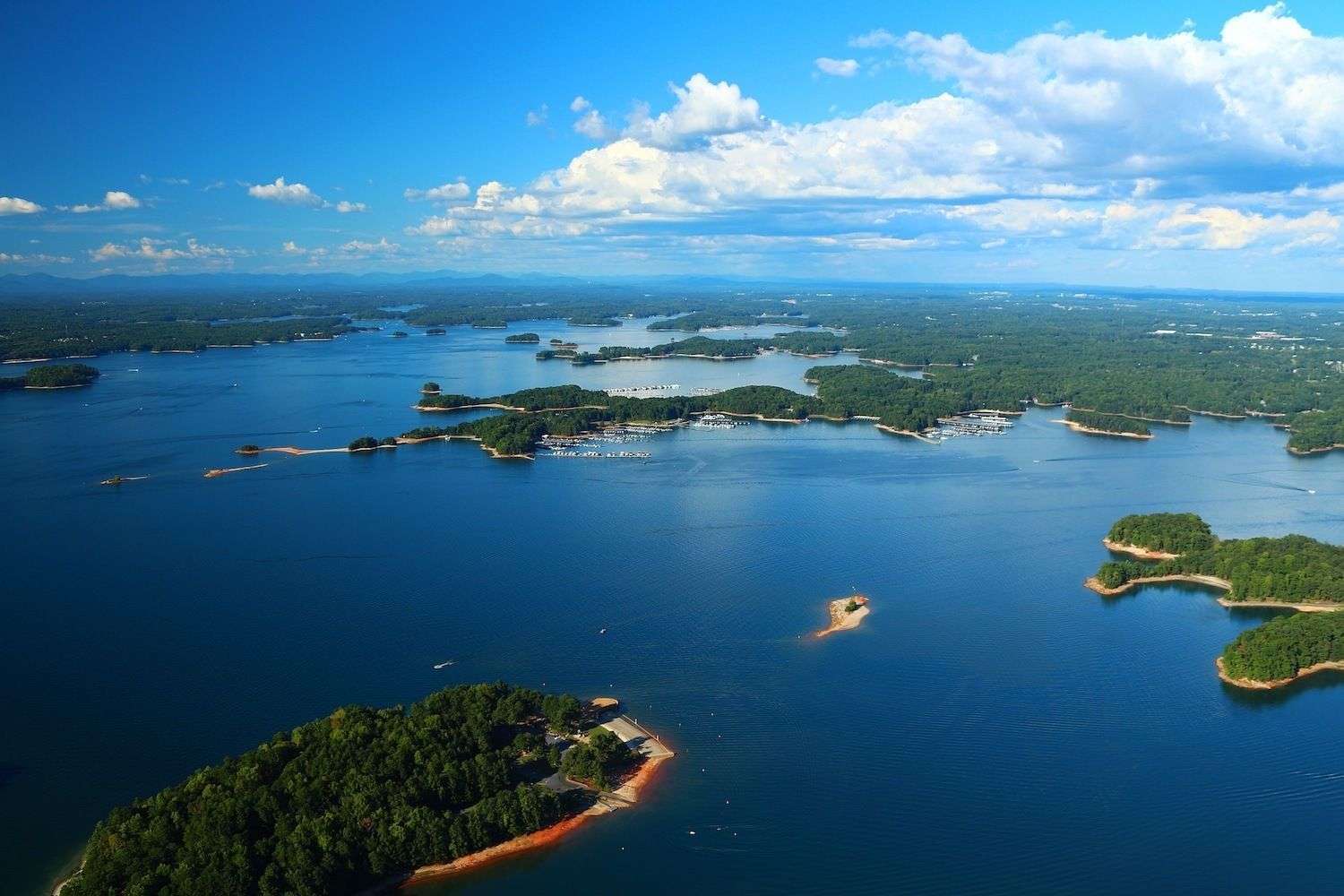
Buford runs along the southern foot of Lake Lanier, with the Buford Dam Road corridor, Lanier Islands, and the Aqualand Marina (Flowery Branch, Hall County) along the Marina basin defining its lake access. The city straddles Gwinnett County and Hall County, with most of the addressed lake inventory in the 30518 and 30519 ZIP codes. The Mall of Georgia, Sugarloaf Mills nearby in Lawrenceville, and the dense Buford Highway and Friendship Road retail spine give the area a deeper everyday-services bench than Flowery Branch carries. Commute geometry leans Gwinnett. Buford sits at the Interstate 985 / Interstate 85 interchange, which gives the city a direct shot south into the Sugarloaf Parkway and Atlantic Station corridors and a clean run north toward Gainesville. The Mall of Georgia exit, Friendship Road, and the Buford Dam Road corridor handle most lake-bound traffic. Households tied to Gwinnett County employers, the Northside Hospital Gwinnett system, or the Gwinnett County Public Schools attendance zones generally find Buford the closer of the two cities. Waterfront inventory on the Buford side is concentrated on Lake Lanier's southern shore, with permitted-dock homes across ZIP codes 30518 and 30519 closing at a median sale price of approximately $1,250,000 across the core Lanier waterfront ZIP set as of March 2026 (Georgia MLS). Inventory leans toward newer construction in the Friendship Road and Buford Dam Road corridors, plus a tear-down candidate set on legacy 1970s and 1980s lake lots that buyers can re-permit and rebuild under the current USACE Mobile District Shoreline Management Plan.
Choose Flowery Branch for Hall County lake lifestyle, historic charm, and South/East Lake access
Flowery Branch is a Hall County lake town anchored on its historic downtown along Main Street and Railroad Avenue, with the South Lake and East Lake shorelines of Lake Lanier running through ZIP code 30542. The city carries a more compact downtown footprint than Buford, with the Flowery Branch Depot, the Old Town Flowery Branch district, and the Atlanta Falcons headquarters and IBM training center on Atlanta Highway shaping the local identity. Lake access spans from the Aqualand Marina basin on the south end to the Sunrise Cove Marina area on the east side. The city sits along Atlanta Highway (Georgia State Route 13) and Spout Springs Road, with Interstate 985 as the primary commute spine north and south. The drive into downtown Atlanta runs roughly 50 to 65 minutes off-peak via I-985 and Interstate 85, with the Gainesville-direction drive taking 15 to 20 minutes for hospital and downtown services. The Cherokee Bluff High School and Flowery Branch High School attendance zones, both inside the Hall County School District, draw a meaningful share of relocating-household demand. Waterfront inventory on the Flowery Branch side includes both South Lake and East Lake shoreline. The 30542 ZIP carries permitted-dock homes priced inside the broader Lake Lanier waterfront band, with a deeper bench of quiet-cove inventory on the East Lake side than Buford's Buford Dam Road corridor typically offers. Land Cove Marina, Holiday Marina, and the Sunrise Cove Marina basin sit within ten to twenty minutes of most Flowery Branch waterfront addresses, and the surrounding lake lots include a mix of legacy 1970s cabins, mid-1990s permitted-dock homes, and a growing share of post-2015 new construction.
The right choice depends on commute, lake access, budget, and daily-life priorities
Commute direction is the cleanest sorting variable between the two cities. Households tied to Gwinnett County employers along the Sugarloaf Parkway, Mall of Georgia, or Interstate 85 corridor generally find Buford the closer city, with shorter run times to Lawrenceville, Duluth, and Suwanee. Households tied to Hall County employers, the Northeast Georgia Medical Center system in Gainesville, or the Atlanta Falcons headquarters on Atlanta Highway generally find Flowery Branch the closer city. The cross-corridor commute from one to the other along Friendship Road and Spout Springs Road is workable but adds time during peak windows. Lake access is the second sorting variable. Buford concentrates on South Lake near the dam, with deeper-water permitted-dock candidates close to the main channel and the Aqualand Marina basin. Flowery Branch spreads across both South Lake and East Lake, with more quiet-cove inventory on the East Lake side and a shorter overall run to the Sunrise Cove and Holiday Marina basins. Buyers prioritizing big-water proximity often lean Buford; buyers prioritizing cove privacy with marina convenience often lean Flowery Branch. Budget cuts differently in each city. Buford's waterfront inventory on the 30518 and 30519 ZIPs runs inside the broader Lanier waterfront median near $1,250,000 as of March 2026 (Georgia MLS), with off-water lake-access inventory near a $675,000 median across the same ZIP set as of March 2026 (Georgia MLS). Flowery Branch's 30542 ZIP carries comparable waterfront pricing with a deeper bench of mid-tier lake-access homes in the Cherokee Bluff and Flowery Branch High School attendance zones. Daily-life weight should drive the final cut: Buford for Gwinnett retail and schools, Flowery Branch for Hall County small-town pattern and the broader East Lake shoreline.
Compare Homes and Lifestyle
Real estate and daily-life patterns diverge between Buford and Flowery Branch on dock geometry, retail and services depth, school attendance zones, and the underlying buyer pool. Both cities sit on Lake Lanier under USACE Mobile District shoreline jurisdiction, but the surrounding municipal services, county overlays, and commute corridors shape meaningfully different ownership experiences.
Lakefront homes, private docks, and marina proximity
Waterfront pricing across both cities sits inside the broader Lake Lanier permitted-dock median of approximately $1,250,000 across ZIP codes 30518, 30519, 30506, 30542, and 30040 as of March 2026 (Georgia MLS). The Buford ZIPs 30518 and 30519 carry a higher concentration of newer construction along the Friendship Road and Buford Dam Road corridors, with permitted single-slip and double-slip docks on the South Lake shoreline. The Flowery Branch ZIP 30542 carries more East Lake quiet-cove inventory and a broader range of legacy permitted-dock homes from the 1970s through 1990s build cycles, with newer construction concentrated in the Spout Springs Road and Cherokee Bluff attendance area. Dock geometry differs by city more than by ZIP. Buford's lake frontage is closer to the main channel and the Buford Dam, which biases inventory toward deeper-water permitted-dock candidates with shorter walks from house to dock. Flowery Branch's East Lake shoreline carries more cove and creek frontage, with shoreline-allocation maps under the 2004 Lake Sidney Lanier Shoreline Management Plan that often allow permitted-dock candidates farther into the coves than the Buford Dam Road corridor allows. Buyers underwriting a specific dock category should pull the USACE shoreline-use permit history and the Exhibit C electrical inspection record before contract on either side. Marina proximity is closely matched across the two cities. Buford anchors near Aqualand Marina at Lake Lanier Islands, Holiday Marina on the south end, and the Lanier Islands marinas inside the resort. Flowery Branch anchors near Sunrise Cove Marina, Holiday Marina, and Aqualand Marina on the south side. Wait-list cadence for slips, dry storage, and fuel access is broadly similar on both sides in peak season, with Lanier Islands carrying the densest amenities footprint and the Sunrise Cove area offering a quieter weekend cadence.
Shopping, dining, roads, schools, parks, and recreation
Retail and services run deeper on the Buford side. The Mall of Georgia, the Friendship Road corridor, and the Buford Highway retail spine concentrate the densest dining, grocery, and services bench in the South Lake market. Northside Hospital Gwinnett in Lawrenceville and Northeast Georgia Medical Center in Gainesville bracket the area on north and south. Flowery Branch carries a smaller but functional retail base along Atlanta Highway and Spout Springs Road, with the historic downtown anchored by the Flowery Branch Depot, the Old Town district, and a growing mix of independent dining and small-business operators. Buyers prioritizing Saturday-errand efficiency lean Buford; buyers prioritizing downtown walkability lean Flowery Branch. School attendance lines split by county. Buford addresses fall inside either Gwinnett County Public Schools, served by the Mill Creek High School cluster on the Gwinnett side, or Hall County Schools and Buford City Schools on the Hall side, with Buford High School as a separate Buford City Schools campus inside the Buford city limits. Flowery Branch addresses sit inside Hall County Schools, with Cherokee Bluff High School and Flowery Branch High School as the two anchor high schools. Buyers relocating around school attendance should pull the current zoning maps from each district before contract, since boundary lines on the South Lake corridor have shifted several times over the past decade. Parks, recreation, and lake-day infrastructure run across both cities. Lake Lanier Olympic Park in Gainesville, the 1996 Olympic rowing and canoe-kayak venue, sits a short drive north of both Buford and Flowery Branch. Don Carter State Park anchors the upper lake near Gainesville. Lanier Islands resort, including Margaritaville at Lanier Islands and the Lanier Islands marinas, sits inside the Buford service area. Public USACE-managed parks and ramps, including Old Federal Park, Vans Pond Park, and the broader Lanier Islands shoreline, give both cities comparable day-use options.
Buyer profiles for each area
Buford fits buyers who weight retail proximity, Gwinnett County school options, and South Lake big-water proximity. The Mall of Georgia corridor, the Friendship Road retail base, and the Buford Dam Road shoreline support a household pattern that uses the lake forty-plus weekends a year while keeping daily errands inside a fifteen-minute radius. Relocating households tied to Gwinnett County employers, the I-85 corridor, or the Sugarloaf Parkway business base typically find Buford the lower-friction choice. Investors evaluating tear-down candidates on the South Lake shoreline also tend to underwrite Buford-side lots given the newer construction comp set. Flowery Branch fits buyers who weight Hall County school attendance, downtown walkability, and East Lake cove inventory. The historic downtown, the Atlanta Highway service base, and the Cherokee Bluff and Flowery Branch High School attendance zones support a household pattern that values small-town pace and a broader cove-side inventory. Second-home and weekend buyers from the metro Atlanta core often weight Flowery Branch because the East Lake shoreline offers quieter cove cadence than the Buford Dam Road corridor, and the drive home along I-985 stays simpler than the Mall of Georgia exit pattern. For both cities, the most common buyer-fit mismatch comes from underestimating how much daily-life pattern matters relative to lake proximity. Buyers who choose Buford for South Lake convenience but spend their workweek tied to Hall County eventually re-trade toward Flowery Branch. Buyers who choose Flowery Branch for the downtown feel but spend their weekends at the Mall of Georgia eventually re-trade toward Buford. The decisive variable is usually the Tuesday-night errand routing, not the Saturday boat-day routing.
Buying or Selling in Buford or Flowery Branch
Transaction strategy on Lake Lanier's south end depends on where the property sits relative to the shoreline allocation map, the dock category permitted under USACE rules, and the county-level overlays that shape both schools and taxes. Buford and Flowery Branch operate under different city and county tax bases, and the positioning playbook for sellers differs accordingly.
How exact shoreline location affects value
Exact shoreline geometry sets the value floor on permitted-dock homes in both cities. Buford's South Lake shoreline along the Buford Dam Road corridor carries deeper main-channel exposure, which supports double-slip and party-dock configurations under the 2004 Lake Sidney Lanier Shoreline Management Plan. Flowery Branch's East Lake shoreline runs more cove and creek frontage, which biases the permitted-dock set toward single-slip and joint-use configurations in the narrower coves. Buyers underwriting a specific lake-use pattern should pull the shoreline allocation classification, the current USACE permit, and the Exhibit C electrical inspection record before contract. Walk-to-water slope is the second value driver. The shoreline along the Buford Dam Road corridor includes both gentle-slope and steep-bank lots, with the gentle-slope set commanding measurable pricing premiums inside the same ZIP and the same dock category. The East Lake shoreline through Flowery Branch carries a similar mix, with the addition of more flat-walk cove lots in the established 1970s and 1980s subdivisions. The USACE vegetation buffer rules and the tram permit guide apply on both sides, and buyers planning a hardscape connection from house to dock should verify what is and is not permitted on the specific lot before contract. Water depth at the dock end, expressed at summer pool elevation 1,071 feet above mean sea level (USACE Mobile District, Lake Sidney Lanier project page, current as of May 2026), drives the third value layer. Buford's main-channel exposure typically delivers consistent depth at the dock through normal lake cycles. Flowery Branch's East Lake coves vary more by cove, with some delivering reliable summer-pool depth and others losing usability during drought drawdowns like the 2007-2009 cycle. Buyers should match the planned watercraft draft to the documented depth history at the specific dock, not the headline cove reputation.
Seller positioning by community, dock type, and convenience
Seller positioning in Buford generally leads with retail and commute access alongside the dock category. South Lake homes inside the Friendship Road and Buford Dam Road corridors benefit from a marketing frame that highlights Mall of Georgia proximity, Interstate 985 access, and the depth of the South Lake main-channel exposure. Homes inside Buford City Schools attendance carry a distinct positioning frame given the separate city school district, and listings should reference both the city school option and the Gwinnett County or Hall County attendance overlay on the same disclosure. Seller positioning in Flowery Branch generally leads with the Hall County lifestyle base, the historic downtown anchor, and the East Lake cove inventory. Listings inside the Cherokee Bluff High School and Flowery Branch High School attendance zones benefit from a marketing frame that highlights the Hall County school overlay, the downtown walkability, and the East Lake cove geometry. Homes along the Spout Springs Road corridor benefit from a separate frame that emphasizes the newer construction set and the established South Lake amenity proximity. For either city, sellers should plan for the disclosure layer well before listing. The current USACE shoreline-use permit, the Exhibit C electrical inspection on the dock, any vegetation buffer modification history, and the most recent septic inspection if the property is not on a sewer connection all belong in the pre-listing package. Sellers who deliver a clean documentation stack at listing typically close inside the broader Lake Lanier days-on-market band; sellers who address documentation reactively typically lose the early-offer window and re-list at a discount.
Schedule a South Lake comparison consultation
Buyers comparing Buford and Flowery Branch generally benefit from a side-by-side walk of two or three candidates in each city before treating either as a default. The two cities share Lake Lanier, ZIP-adjacent inventory bands, and the USACE shoreline framework, but the daily-life pattern, the school attendance overlays, and the lake-access geometry diverge enough that the comparison rarely sorts cleanly on a spreadsheet. A South Lake comparison consultation typically pairs a Saturday tour of the Buford Dam Road and Friendship Road corridors with a follow-up tour of the Flowery Branch downtown and East Lake shoreline. Sellers preparing to list inside either city benefit from a comparable pre-listing positioning review. The review covers the USACE shoreline-use record, the Exhibit C electrical inspection cycle on the dock, septic and well documentation where applicable, county tax overlays, and the school attendance zone as it currently sits on the Hall County, Gwinnett County, or Buford City Schools maps. Sellers who walk the positioning review before pricing typically capture the early-offer window at list; sellers who skip it typically re-price within thirty days. Ashley Smith, real estate agent with The Dream Smith Team at Compass, advises buyers and sellers comparing the two cities to anchor the decision on documented USACE, county, and school-district records rather than category assumptions. Both Buford and Flowery Branch are durable South Lake Lanier markets, but they reward different priorities and different household patterns.
Frequently Asked Questions
- Is Buford or Flowery Branch closer to Lake Lanier?
- Both cities sit directly on Lake Lanier. Buford runs along the lake's southern foot at Buford Dam, with the Buford Dam Road corridor and Lanier Islands as the primary lake-access spine. Flowery Branch runs along the East Lake shoreline in Hall County, with downtown about a mile inland from the closest cove and waterfront homes inside ZIP 30542. Both cities are roughly equidistant to the core South Lake marinas, including Aqualand Marina and Holiday Marina.
- Which city has higher waterfront home prices, Buford or Flowery Branch?
- Waterfront pricing in both cities sits inside the broader Lake Lanier permitted-dock band, with a median sale price of approximately $1,250,000 across ZIP codes 30518, 30519, 30506, 30542, and 30040 as of March 2026 (Georgia MLS). Buford ZIPs 30518 and 30519 carry a higher share of newer construction along the Buford Dam Road corridor. Flowery Branch ZIP 30542 carries more East Lake cove inventory and a deeper mix of legacy permitted-dock homes from the 1970s through 1990s build cycles. Inventory mix differs more than headline price between the two.
- What school districts serve Buford and Flowery Branch?
- Buford addresses fall inside either Gwinnett County Public Schools, served by the Mill Creek High School cluster on the Gwinnett side, or Hall County Schools on the Hall side, with Buford City Schools operating as a separate city district inside the Buford city limits. Flowery Branch addresses sit inside Hall County Schools, with Cherokee Bluff High School and Flowery Branch High School as the two anchor high schools. Buyers should pull current zoning maps before contract since South Lake attendance lines have shifted multiple times.
- Is the commute to Atlanta shorter from Buford or Flowery Branch?
- Both cities use Interstate 985 and Interstate 85 as the primary commute corridor into Atlanta, with run times of roughly 45 to 65 minutes off-peak depending on exact address and destination. Buford sits closer to the I-985 / I-85 interchange and the Mall of Georgia exit, which biases the commute toward Gwinnett County employers along Sugarloaf Parkway. Flowery Branch sits a few exits north on I-985, which biases the commute toward Hall County employers and the Northeast Georgia Medical Center system in Gainesville.
- Which city has more retail and dining options?
- Buford carries a deeper retail and dining bench, anchored by the Mall of Georgia, the Friendship Road corridor, and the Buford Highway service spine. Flowery Branch carries a smaller but growing base along Atlanta Highway and in the historic downtown along Main Street, with the Flowery Branch Depot and the Old Town district as the walkable core. Buyers prioritizing Saturday-errand efficiency typically lean Buford; buyers prioritizing downtown walkability and small-business density typically lean Flowery Branch.
- Which is better for a permitted-dock waterfront home, Buford or Flowery Branch?
- Both cities support permitted-dock waterfront homes under the 2004 Lake Sidney Lanier Shoreline Management Plan administered by the USACE Mobile District. Buford's South Lake shoreline near Buford Dam carries deeper main-channel exposure, which supports more double-slip and party-dock configurations. Flowery Branch's East Lake shoreline runs more cove and creek frontage, which biases inventory toward single-slip and joint-use dock configurations with quieter cove cadence. The right fit depends on the planned lake-use pattern.
Related
- Buford GA Lakefront HomesBuford waterfront inventory across the South Lake Lanier shoreline in Gwinnett and Hall counties.
- Flowery Branch GA Lakefront HomesFlowery Branch waterfront inventory along the South Lake and East Lake shoreline in Hall County.
- South Lake Lanier HomesCommunity guide to South Lake Lanier real estate, marinas, and lifestyle from Buford to Flowery Branch.
- Buford GA Homes for SaleAll Buford homes for sale, including waterfront, lake-access, and inland inventory.
- Flowery Branch GA Homes for SaleAll Flowery Branch homes for sale, including waterfront, lake-access, and downtown inventory.
- Lake Lanier Commute to AtlantaDrive-time, route, and traffic patterns from Lake Lanier cities into Atlanta along I-985 and I-85.
- Lake Lanier School Districts GuideAttendance zones, district overlays, and high school clusters across the Lake Lanier shoreline.