
Buyer Guide
Buford GA lakefront homes are waterfront and lake-access residences on the south shore of Lake Sidney Lanier, concentrated along Buford Dam Road and Lanier Islands Parkway in Gwinnett County, with a smaller stretch crossing into southern Hall County. The defining variable on this shoreline is school district: parcels inside the independent Buford City Schools attendance boundary routinely trade at a 10 to 15 percent premium over otherwise comparable lots feeding Lanier High and the Gwinnett County Public Schools cluster. Beyond schools, buyers should verify the U.S. Army Corps of Engineers dock permit, cove depth at winter pool, slope to water, and county of record before any offer.
Lakefront Living in Buford
Lakefront living in Buford means south-shore Lake Lanier access within roughly 40 minutes of downtown Atlanta, combined with the city's own Buford City Schools district and the Mall of Georgia retail corridor along I-985. Buyers shopping the south shore consistently weigh three things against each other before they tour: commute, school zone, and dock.
South Lake convenience and Atlanta access
Buford sits at the southern end of Lake Lanier and at the intersection of I-985 and the Sugarloaf Parkway corridor that connects to I-85, which is the practical reason south-shore lakefront here trades on a different curve than the north end of the lake. Off-peak drive time from a Buford Dam Road lakefront house to downtown Atlanta runs roughly 45 to 55 minutes; rush-hour drive time pushes closer to 75 to 90 minutes. Hartsfield-Jackson Atlanta International Airport sits about 60 minutes south off-peak. That commute envelope is the reason a meaningful share of south-shore Lake Lanier inventory in Buford trades as primary residence rather than second home. Buyers commuting to Atlanta full-time can hold a true lakefront address and still keep a workable in-office schedule, which is a structurally different buyer profile than the Gainesville or Dawsonville shoreline tends to attract. Inside the city, GA-20 cuts east-west through Historic Downtown Buford toward Cumming and GA-400, and Buford Highway / GA-13 runs parallel to I-985 as the older commercial spine.
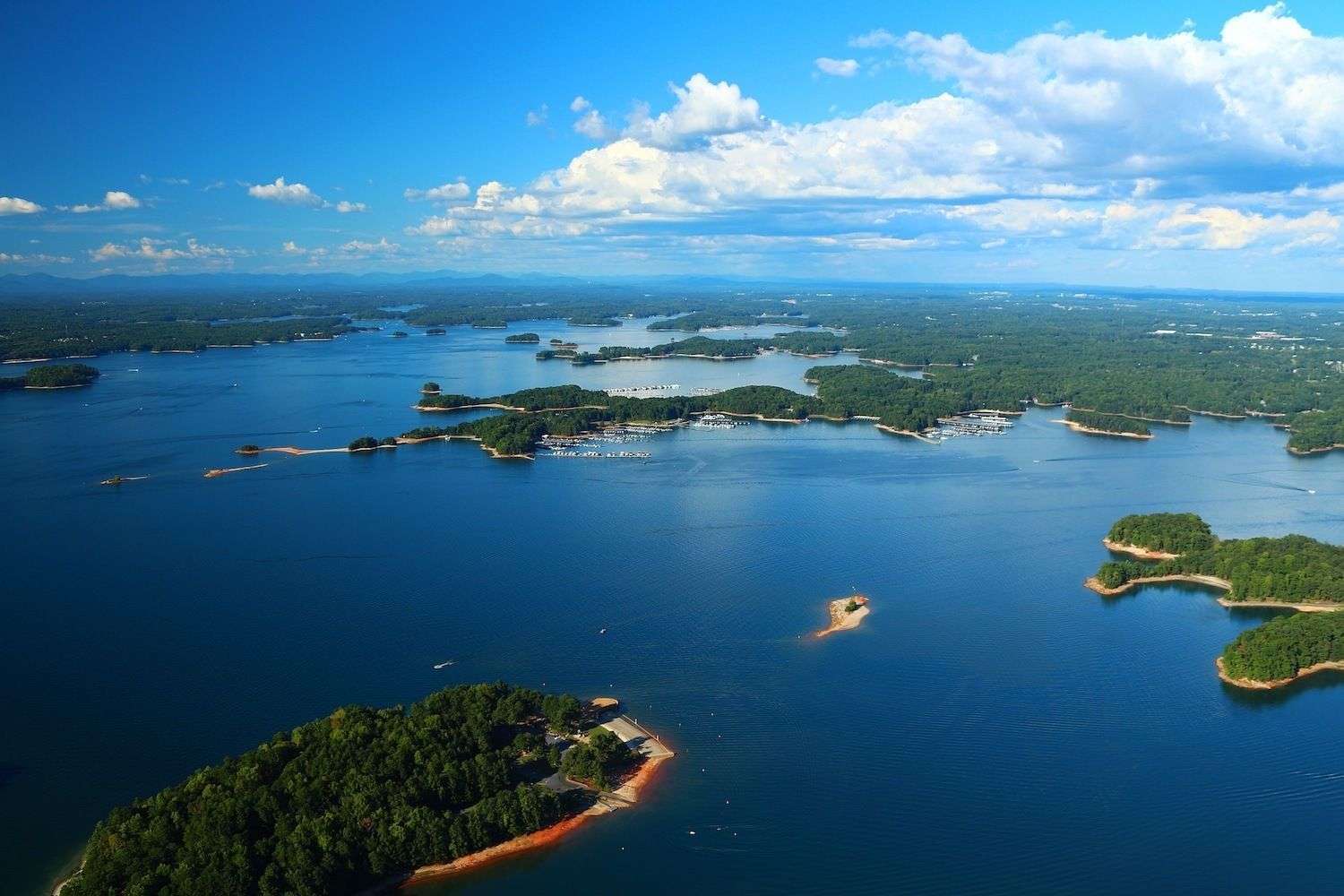
Waterfront homes, boat ramps, marinas, and retail proximity
The south-shore waterfront inventory in Buford clusters along Buford Dam Road, with the Buford Dam itself and the U.S. Army Corps of Engineers Lake Lanier Project Management Office anchoring the north end of the road. Lanier Islands Parkway carries the marina and resort traffic east toward Lake Lanier Islands and Margaritaville at Lanier Islands. Public boat ramps along the south shore include the Lower Pool Park ramp below the dam, the Vann's Tavern Park ramp on the west side of the south shore, and the Shoal Creek Park ramp. What separates south-shore Buford from the rest of the lake is the layering of waterfront with full-service retail. The Mall of Georgia opened in 1999 about ten minutes south of Buford Dam Road and reset the city's commercial center of gravity; Tannery Row sit within the same fifteen-minute drive envelope. Buyers looking at a Cumming or Dawsonville lakefront house generally accept a longer drive for groceries, dining, and big-box retail; Buford lakefront buyers do not have to.
How Buford fits commuters, boaters, and luxury buyers
Buford lakefront fits three buyer profiles that the broader Lake Lanier market does not assemble as cleanly. Commuter-buyers want a true lakefront address inside a workable Atlanta drive, and the I-985 / Sugarloaf Parkway / I-85 path holds that envelope. Boater-buyers want deep-water cove access and a transferable Corps of Engineers dock permit, and the south-shore coves off Buford Dam Road consistently hold water at winter pool because the lake operates near the dam's outflow. Luxury buyers in this segment generally evaluate Buford City Schools attendance, dock permit class, and main-channel access in that order. Inventory above the $1,500,000 mark on the south shore is small and slow-turning, and the top of the tier — homes priced above $3,000,000 — frequently transacts off-market or as private MLS listings, similar to the Cumming and northern Hall County luxury segments.
What to Know Before Buying in Buford
Before an offer goes in on a Buford lakefront home, three categories of due diligence carry more weight than the headline asking price: dock and shoreline status, weekend boat traffic and seasonality, and county-and-school-district of record. Each of these can move final value by six figures.
Private dock availability and water access
Not every Buford lakefront parcel carries a private dock permit. Lake Lanier is federally owned and the U.S. Army Corps of Engineers, Mobile District, controls every shoreline use permit. Some south-shore lots in Buford hold a current transferable private Corps dock permit; others share a community dock through a homeowners association; a smaller number have no dock eligibility at all because of cove width, neighboring docks, or shoreline-use designation. Deep-water lots — typically defined as parcels that hold at least eight to ten feet of water at the dock end at winter pool elevation 1,070 feet — keep full-size pontoons and wakeboats in the water year round, including through drought cycles like those Lake Lanier experienced in 2007 and 2012. Cove width and shoreline orientation matter as well: wide-mouth coves and main-channel exposure allow double-slip and party-dock configurations where the Corps shoreline-use plan permits them. Verifying the permit class, slip count, gangway length, and compliance status before an offer is essential.
Weekend boat traffic and South Lake lifestyle
The south shore at Buford is the busiest segment of Lake Lanier from May through September because it sits adjacent to Lake Lanier Islands, Margaritaville at Lanier Islands, and the highest-density cluster of marinas on the lake. Holiday Marina, Aqualand Marina (Flowery Branch, Hall County), and Sunrise Cove Marina all sit within a short run of the Buford Dam Road shoreline, and weekend boat traffic on the main channel between Memorial Day and Labor Day runs heavier than anywhere else on the reservoir. Buyers who plan to live on the lake year round generally accept that trade-off; buyers using the home as a quiet weekend retreat sometimes shortlist a quieter Hall County cove instead. The seasonal pattern is the inverse in winter — the south shore quiets sharply from November through March, and full-time residents along Buford Dam Road describe the off-season as effectively private. Listings posted between March and June consistently transact faster than fall and winter listings because boating-season buyers tour with the dock in mind.
Gwinnett County considerations and local amenities
Most of Buford sits in Gwinnett County, with a smaller portion crossing into southern Hall County along the northeastern edge of the city. The county distinction matters because property tax millage, voting precincts, and the assigned county school district all change at the county line, even though the city itself operates as a single municipality. Gwinnett County addresses outside the Buford City Schools attendance area feed the Lanier Cluster — Lanier High and Lanier Middle — within Gwinnett County Public Schools. Local amenities cluster across three corridors. Historic Downtown Buford and Tannery Row anchor walkable dining and the Bowen Center for the Arts. The Mall of Georgia corridor along I-985 carries large-format retail, and Andretti Indoor Karting. The Lake Lanier south shore itself, accessed off Buford Dam Road and Lanier Islands Parkway, anchors boating, the U.S. Army Corps of Engineers Buford Dam, and the marina districts.
Buying or Selling Buford Lakefront Property
Transacting a Buford lakefront home turns on a different set of verification steps than a non-waterfront Buford home or a non-Buford Lake Lanier home, because two pricing logics overlap on the south shore: the Buford City Schools premium and the Corps of Engineers dock permit premium.
Buyer due diligence around docks and shoreline
Six items belong on a buyer's verification checklist before an offer on a Buford lakefront home. First, pull the U.S. Army Corps of Engineers shoreline-use permit on file for the parcel and confirm permit class, slip count, gangway length, and current transferability. Second, measure or request a sonar reading of cove depth at winter pool, not summer pool. Third, walk the slope from the house to the dock; steep lots may need a tram or extensive stair structure, and septic field placement on a slope can constrain expansions. Fourth, confirm county of record — Gwinnett County versus Hall County — because millage rates and the assigned county school district both change at the line. Fifth, confirm whether the parcel sits inside the Buford City Schools attendance boundary; that single detail can carry a 10 to 15 percent valuation effect. Sixth, request the Corps shoreline-use map for the cove to check for any adjacent green-zone designation, dock-density cap, or permitted-but-unbuilt neighboring dock that could block view or access.
Seller positioning for convenience, access, and lifestyle
Sellers of Buford lakefront homes generally position around three signals that buyers shopping the south shore actively look for. First, school zone clarity: stating in the listing whether the parcel sits inside the Buford City Schools attendance boundary or in the Gwinnett County Public Schools Lanier Cluster removes a buyer-side verification step and broadens the qualified pool. Second, dock specifics: posting the Corps of Engineers permit class, slip count, gangway length, and winter-pool cove depth puts the home in front of dock-first buyers who otherwise filter it out. Third, commute envelope: south-shore listings consistently benefit from naming I-985, Sugarloaf Parkway, and the I-85 connection in the listing copy because commuter-buyers searching Lake Lanier filter for drive time before they filter for finishes. Median sale price for single-family homes in Buford was approximately $585,000 as of April 2026 (Georgia MLS, ZIP codes 30518 and 30519); waterfront and lake-access homes along Buford Dam Road sit in their own band and often clear above $1,000,000.
Schedule a Buford lakefront consultation
A south-shore Buford lakefront consultation typically begins with three filters before any tour: school district, dock permit class, and commute corridor. Buyers send a parcel address or saved search through the contact form or the Buford listings page, and the conversation starts from the public record on that property: parcel APN, county of record, Buford City Schools attendance status, and any visible Corps of Engineers permit history. For active inventory, the Buford listings page tracks current homes for sale across the city, and the Lake Lanier private dock homes page filters specifically for true waterfront with a transferable Corps permit. For a wider read across the lake, the Lake Lanier lakefront homes hub compares Buford to Cumming, Gainesville, Flowery Branch, and the smaller Dawsonville segment. All conversations are no-pressure and start from the buyer or seller's actual question, not a generic sales template.
Frequently Asked Questions
- What is the difference between Buford City Schools and Gwinnett County Schools for lakefront buyers?
- Buford City Schools is an independent K–12 city school district, separate from Gwinnett County Public Schools and Hall County Schools. Only parcels inside the defined attendance boundary feed Buford Elementary, Buford Middle, and Buford High School. Lakefront parcels along Buford Dam Road sit on both sides of that boundary, and homes inside the city school district consistently trade at a 10 to 15 percent premium over otherwise comparable lakefront homes that feed Lanier High in Gwinnett County Public Schools.
- How much do Buford GA lakefront homes cost?
- Waterfront and lake-access homes along Buford Dam Road and Lanier Islands Parkway typically clear above $1,000,000, with true lakefront homes that hold a transferable U.S. Army Corps of Engineers dock permit generally trading in line with the broader Lake Lanier median of approximately $1,250,000 as of March 2026 (Georgia MLS, ZIP codes 30518, 30519, 30506, 30542, and 30040). South-shore luxury inventory above $3,000,000 is small and slow-turning. Non-waterfront Buford single-family homes posted a median near $585,000 as of April 2026 (Georgia MLS).
- Do all Buford lakefront homes come with a private dock permit?
- No. Lake Lanier is federally owned and the U.S. Army Corps of Engineers, Mobile District, controls every shoreline use permit. Some Buford south-shore lots hold a current transferable private dock permit, others share a community dock through a homeowners association, and a smaller number have no dock eligibility at all due to cove width, neighboring docks, or shoreline-use designation. Buyers verify permit class, slip count, gangway length, and current compliance status before any offer.
- How does the south shore at Buford compare to the north shore at Gainesville?
- The south shore at Buford carries heavier weekend boat traffic from May through September because it sits adjacent to Lake Lanier Islands and the highest-density marina cluster on the lake. South-shore coves near Buford Dam tend to hold water more reliably at winter pool because the lake operates near the dam outflow. The north shore at Gainesville and Hall County offers quieter coves, more shoreline mileage, and lower millage in some segments, but a longer commute to Atlanta and a different school-district mix.
- How long do Buford lakefront homes stay on the market?
- Lake Lanier waterfront listings averaged about 58 days on market in Q1 2026 (Georgia MLS, April 2026 report), and Buford-specific waterfront tracks close to that average. Buford single-family listings overall averaged 41 days on market in Q1 2026. Listings posted between March and June consistently transact faster than fall and winter listings because boating-season buyers are actively touring docks. Deep-water lots with current dock permits inside Buford City Schools frequently move below those averages.
- Where is Buford Dam and what does access to it mean for lakefront buyers?
- Buford Dam closed the Chattahoochee River in 1956 and formed Lake Sidney Lanier. The dam sits on Buford Dam Road just north of Historic Downtown Buford, and the U.S. Army Corps of Engineers Lake Lanier Project Management Office sits at the dam itself. For lakefront buyers, proximity to the dam matters because the south-shore coves near the dam are deeper and more consistently hold water at winter pool elevation, which protects year-round dock usability. The Lower Pool Park ramp below the dam serves the river side.
Related
- Buford, GA Community GuideFull Buford profile: history, market data, Buford City Schools, Tannery Row, and the Mall of Georgia corridor.
- Buford Homes for SaleCurrent Buford single-family and waterfront inventory tracked from Georgia MLS.
- Gwinnett County Lake Lanier HomesSouth-shore Lake Lanier inventory across the Gwinnett County footprint, including Buford and Sugar Hill.
- Lake Lanier Lakefront HomesHub page covering all five lakefront counties — Hall, Forsyth, Gwinnett, Dawson, and Lumpkin.
- Lake Lanier Private Dock HomesTrue private-dock waterfront with transferable U.S. Army Corps of Engineers permits.